
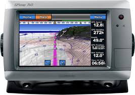
GPSMAP 720
GPSMAP 720 is a stand-alone touchscreen chartplotter that brings a new level of functionality to your vessel. Featuring a brilliant 7 in (17.78 cm) display, GPSMAP 720 puts all the information you need right at your fingertips. GPSMAP 720 is preloaded with a worldwide basemap and accepts additional map data for greater flexibility. In addition, GPSMAP 720 accepts radar input and offers full NMEA 2000® connectivity for greater convenience when adding extra sensors.
View Worldwide Basemap
GPSMAP 720 comes with a worldwide basemap and features an internal, high-sensitivity GPS receiver for superior satellite tracking and quicker acquisition times. And as an added benefit, GPSMAP 720 can receive graphical weather data for North America through the optional GXM™ 51 satellite receiver/antenna.
Take Control by Touch
Input is easy with GPSMAP 720. Whether you’re changing course or simply reviewing information in front of you, the intuitive touchscreen interface makes for simple operation. The device also offers flexible brightness levels for daytime readability along with low-light dimming during night use. And with a widescreen display that’s rugged and waterproof, it’s made to perform in any situation.
Expand with Radar
Featuring a built-in radar port, GPSMAP 720 can be interfaced with Garmin’s line of affordable GMR™ marine radar systems. Whether you’re adding radar now or in the future, you’ll enjoy the convenience of plug-and-play installation as well as the power, range and high-definition targeting of our proven radar offerings.¹
Add Extras with BlueChart® g2 Vision®
With the optional BlueChart g2 Vision SD™ card, you can add a whole new dimension of exceptional features to your chartplotter.
- MarinerEye view and FishEye view provide a 3-D perspective of map information, both above and below the waterline.
- High-resolution satellite images and aerial photographs help you orient yourself in unfamiliar areas.
- Auto Guidance technology searches through all relevant charts to create a route you can actually follow — one that avoids obstacles, shallow water, buoys and other obstructions.
¹Garmin Marine Network not supported.
Specifications :
Physical & Performance: |
|
| Unit dimensions, WxHxD: | 8.8" x 5.6" x 3.1" (22.4 x 14.2 x 7.9 cm) |
| Display size, WxH: | 6.0" x 3.6", 7.0" diagonal (15.2 x 9.1 cm, 17.8 cm diagonal) |
| Display resolution, WxH: | 800 x 480 pixels |
| Display type: | WVGA display |
| Weight: | 2.48 lb (1.1 kg) |
| Battery: | none |
| Battery life: | none |
| Waterproof: | yes (IPX7) |
| High-sensitivity receiver: | yes |
| Antenna: | internal |
| NMEA input/output: | NMEA 0183 compatible and NMEA 2000® certified |
Maps & Memory: |
|
| Basemap: | yes |
| Preloaded maps: | no |
| Ability to add maps: | yes |
| Built-in memory: | none (cannot load maps to internal memory) |
| Accepts data cards: | SD™ card slot |
| Waypoints/favorites/locations: | 3,000 |
| Routes: | 100 |
| Track log: | 20,000 points; 50 saved tracks |
Features & Benefits: |
|
| Garmin radar compatible: | yes |
| Garmin sonar compatible: | no |
| Garmin Marine Network™ compatible: | no |
| Touchscreen: | yes |
| Supports AIS (tracks target ships' position): | yes |
| Supports DSC (displays position data from DSC capable VHF radio): | yes |
| Audible alarms: | yes |
| Tide tables: | yes |
| Hunt/fish calendar: | no |
| Sun and moon information: | yes |
| 3-D map view: | yes (with optional BlueChart g2 Vision card) |
| Auto Guidance: | yes (with optional BlueChart g2 Vision card) |
| XM WX Weather & Radio for U.S. & Canada compatible: | yes |
| Automatic routing (turn by turn routing on roads): | no |
| Voice prompts (e.g. "Turn right in 500 ft."): | no |
| Speaks street names (e.g. "Turn right ON ELM STREET in 500 ft."): | no |
| Headphone jack/audio line-out: | no |
| Audio/video input/output: | no |
| Portable: | no |
| Automotive/motorcycle-friendly: | |


